Sep 21, 2024 BLOG
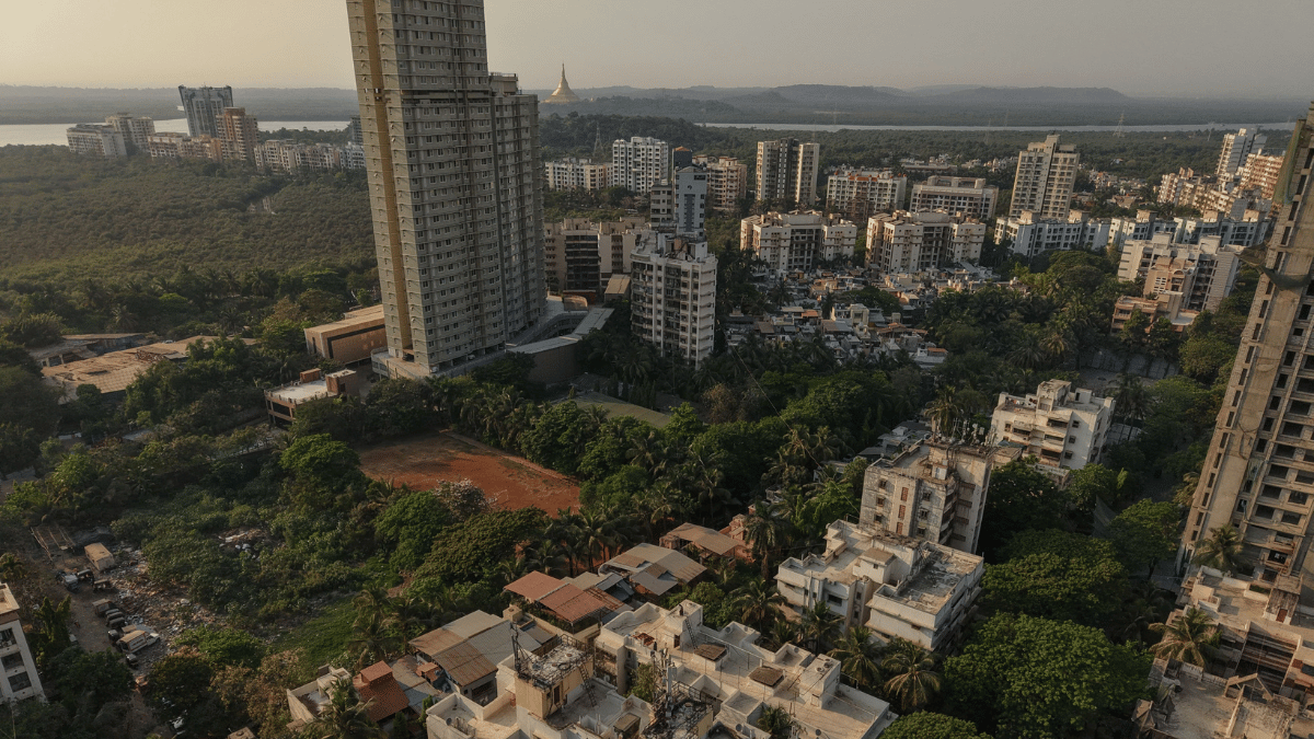
Buying a property is no longer just about seeing four walls and a floor plan. Buyers want to understand the entire property, its surroundings, amenities, access roads, and development potential before making a decision.
This is where drones in real estate India are creating a new advantage. From capturing high-quality aerial photographs to inspecting large properties and showcasing surrounding infrastructure, drone technology is helping real estate professionals present and evaluate properties more effectively.
Drone technology in real estate involves using UAVs equipped with high-resolution cameras, thermal sensors, or mapping systems to capture aerial information about properties and their surroundings.
Instead of depending entirely on ground-level photographs or manual inspections, real estate developers, agents, and property owners can obtain a broader view of a site in a relatively short time.
Common applications include:
The right application depends on the property’s size, inspection requirements, and the type of information needed.
1. Better Property Marketing and Advertising
First impressions matter in real estate. Professional drone real estate photography can provide an aerial perspective that conventional ground-level photographs cannot easily capture.
Aerial images and videos can show the complete property, landscaping, access roads, nearby developments, and the relationship between different parts of a site.
For developers and real estate agencies, these visuals can be used across:
This gives potential buyers a more complete visual understanding of the property before arranging a physical visit.
2. Faster and Safer Property Inspection
Large properties can be difficult and time-consuming to inspect manually, particularly when rooftops, elevated structures, or restricted areas are involved.
Drone property inspection provides an aerial view of these areas without requiring inspectors to physically access every section during the initial assessment.
High-resolution imagery can help identify visible issues such as:
The captured imagery also creates a documented visual record that can be reviewed later by property managers, engineers, or other stakeholders.
3. High-Quality Aerial Photography
One of the most established applications of drones in real estate is aerial photography.
A drone can capture different perspectives of a property, from close aerial views to wider shots showing the complete site and its surroundings. These images can make property listings more informative and visually engaging.
For large residential projects, commercial developments, resorts, industrial properties, and plotted developments, aerial photography can communicate the scale and layout of a site much more effectively than a limited set of ground photographs.
4. Better Visualization of Large Properties
Large residential projects, commercial developments, resorts, and plotted communities can be difficult to understand through ground-level photographs alone. Drones in real estate provide an aerial perspective that shows the property’s overall layout, scale, and relationship between different areas.
Aerial imagery can help potential buyers visualize roads, open spaces, buildings, landscaping, parking areas, and other features before visiting the property.
What Aerial Views Can Show
This broader perspective can make property presentations more informative and help buyers understand the development beyond individual photographs.
5. Showcase Nearby Amenities and Surroundings
A property’s value is influenced not only by the building itself but also by its surrounding environment. Real estate aerial photography can provide a wider view of nearby roads, commercial areas, schools, parks, transportation links, and other visible amenities.
Instead of showing buyers only the property boundary, developers and agents can use aerial imagery to communicate how the development fits into its surrounding area.
This can be particularly useful for:
Aerial visuals can therefore provide prospective buyers with additional context when evaluating a property.
6. Save Time and Reduce Inspection Costs
Traditional methods of capturing aerial views may require expensive equipment or additional resources, particularly when large areas need to be documented. Drones provide a compact and flexible alternative for many real estate applications.
A single planned drone operation can capture extensive visual information within a relatively short period. This can reduce the time required for preliminary site documentation and limit the need for repeated physical visits.
The potential benefits include:
The actual cost and time savings depend on project size, location, regulatory requirements, equipment, and the type of deliverables required.
7. Support Construction and Property Monitoring
The role of drone technology for real estate in India extends beyond property marketing. Developers can also use aerial imagery to document construction progress and maintain a visual record of a project over time.
Regular drone surveys can capture changes across a construction site, allowing project teams and stakeholders to compare different stages of development.
Applications in Real Estate Development
When combined with photogrammetry and mapping workflows, drone data can provide more than photographs. It can support detailed site visualization and, where appropriately surveyed and processed, measurable geospatial outputs.
The growing use of drones is moving real estate marketing and site documentation beyond conventional photography. Drone technology in real estate allows developers and property professionals to combine compelling visual content with useful information about the property and its surroundings.
From drone real estate photography and marketing videos to property inspections and construction monitoring, UAVs can support multiple stages of the real estate lifecycle.
For companies handling large developments, the ability to capture repeatable aerial data can also create a useful record for communication, monitoring, and future reference.
The role of drones in real estate is expanding beyond photography and promotional videos. As drone mapping, photogrammetry, and advanced sensors become more accessible, UAVs can support property documentation, inspection, construction monitoring, and site visualization.
For developers and real estate professionals, the value lies in combining aerial imagery with useful project information. Instead of simply showing a property from above, drone-based data can help create a more complete picture of the site and its surroundings.
Drones in real estate India are changing how properties are presented, inspected, and documented. From high-quality aerial photography and property marketing to building inspections and construction monitoring, drones can support multiple stages of the real estate lifecycle.
As the industry becomes increasingly visual and data-driven, drone technology in real estate offers developers, agents, and property owners a practical way to capture better information and present properties more effectively.
1. How are drones used in real estate?
Drones are used for aerial photography, property marketing, building inspection, site documentation, construction monitoring, and capturing views of surrounding infrastructure and amenities.
2. What are the benefits of drones in real estate?
Key benefits include faster aerial data collection, high-quality property visuals, improved site visualization, safer preliminary inspections, and efficient documentation of large properties.
3. Can drones be used for property inspection?
Yes. Drone property inspection can capture detailed aerial imagery of rooftops, external structures, and difficult-to-access areas, helping identify locations that may require further inspection.
4. Can drones help sell real estate properties?
Drone photography and aerial videos can provide potential buyers with a broader view of a property, its layout, surroundings, access roads, and nearby amenities, making property marketing more informative.
5. Can drones monitor real estate construction projects?
Yes. Developers can use periodic aerial imagery to document construction progress, compare different stages of development, and maintain a visual record of the project.
6. What is drone mapping for real estate?
Drone mapping for real estate uses aerial imagery and photogrammetry to create detailed maps, orthomosaics, 3D models, and other spatial outputs for property and site documentation.