Sep 29, 2025 BLOG
Natural disasters are becoming more frequent and intense, leaving communities and emergency responders with little time to react. From devastating floods and wildfires to earthquakes and dam failures, timely information is critical for saving lives, minimizing damage, and coordinating rescue efforts.
Traditional ground surveys often take hours—or even days—to assess affected areas, especially when roads are blocked or conditions are unsafe. Today, drones in disaster management are changing this approach by providing real-time aerial intelligence, allowing authorities to respond faster, safer, and more effectively.
Equipped with high-resolution cameras, thermal sensors, and advanced mapping technology, disaster management drones can quickly assess damage, locate affected areas, and support rescue operations. As UAV technology continues to evolve, it is becoming an indispensable tool for governments, disaster response agencies, and infrastructure organizations across India.
In this article, we’ll explore how drones are improving disaster preparedness, emergency response, and post-disaster recovery through real-world applications and advanced geospatial intelligence.
Every disaster presents unique challenges, but one requirement remains the same—rapid access to accurate information. Whether it’s a flooded village, a collapsed building, or a wildfire spreading across a forest, decision-makers need a clear picture of the situation before deploying resources.
Modern UAV disaster management solutions enable emergency teams to collect critical aerial data without exposing personnel to hazardous environments.
By providing actionable insights within minutes, drone disaster response solutions help authorities make informed decisions and improve operational efficiency during emergencies.
Wildfires can spread rapidly, making it difficult for firefighters to monitor the situation from the ground. Dense smoke, rough terrain, and extreme heat often limit visibility and delay response efforts.
Drones in wildfire monitoring provide a safe and efficient alternative by delivering real-time aerial imagery and thermal intelligence. Emergency teams can quickly identify hotspots, track the fire’s movement, and plan containment strategies without putting personnel at unnecessary risk.
With improved situational awareness, drone surveillance during disasters enables faster response, better resource allocation, and more effective wildfire management.
After a disaster, assessing damage quickly is essential for planning rescue and recovery operations. However, inspecting unstable buildings, bridges, and critical infrastructure can be dangerous for field teams.
Using high-resolution cameras, LiDAR, and photogrammetry, disaster assessment using drones allows authorities to inspect affected structures remotely while capturing accurate aerial data.
By reducing inspection time and improving data accuracy, drone disaster mapping helps emergency agencies respond more efficiently while minimizing risks to personnel.
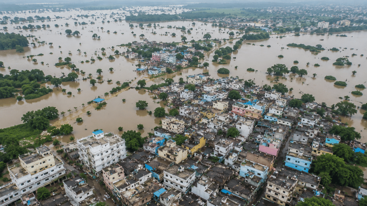
Floods are among the most common natural disasters in India, often disrupting transportation, communication, and access to affected communities. In such situations, drones for flood rescue provide emergency responders with a rapid aerial view of the affected region, helping them assess the situation without delay.
Using high-resolution and thermal cameras, flood mapping drones can identify submerged roads, monitor rising water levels, and locate stranded individuals. This real-time information enables disaster response teams to prioritize rescue operations and allocate resources more effectively.
By improving situational awareness, drone disaster response enables authorities to respond faster while reducing risks to rescue personnel.
Earthquakes can severely damage buildings, roads, and public infrastructure, making rescue operations both complex and hazardous. Entering unstable structures without prior assessment can put emergency responders at significant risk.
Modern drones for earthquake response provide a safer alternative by capturing high-resolution aerial imagery and thermal data before ground teams are deployed. These aerial insights help identify collapsed structures, blocked access routes, and high-risk zones.
By combining aerial intelligence with GIS analysis, UAV emergency services help authorities make faster, data-driven decisions during critical rescue missions.
Dams and reservoirs require continuous monitoring to identify structural issues before they become major safety concerns. During periods of heavy rainfall or extreme weather, timely inspections are essential for protecting downstream communities and critical infrastructure.
Using high-resolution cameras, LiDAR, and advanced mapping technology, drone disaster mapping enables engineers and authorities to inspect dam walls, spillways, embankments, and surrounding terrain quickly and safely.
With faster inspections and accurate geospatial data, UAV disaster management strengthens preventive maintenance and improves disaster preparedness.
As drone technology continues to evolve, its role in disaster management will extend far beyond aerial photography. Artificial Intelligence (AI), LiDAR, cloud-based analytics, and real-time GIS platforms are enabling faster damage assessments and smarter emergency planning.
Future disaster management drones will increasingly support predictive risk analysis, automated damage detection, digital twin creation, and integrated emergency response systems. These advancements will help governments and disaster management agencies improve preparedness, accelerate recovery, and build more resilient communities.
Natural disasters require rapid, informed, and coordinated action. From drones in wildfire monitoring and drones for flood rescue to disaster assessment using drones, drone disaster mapping, and drones for earthquake response, UAV technology is transforming the way emergency teams respond to crises.
By providing real-time aerial intelligence, improving responder safety, and delivering accurate geospatial data, drones have become an essential tool for modern disaster management. As technology advances, their role in safeguarding lives, infrastructure, and communities across India will only continue to grow.
Drones are used for aerial mapping, damage assessment, flood monitoring, wildfire detection, infrastructure inspection, and search and rescue operations, helping emergency teams respond quickly and safely.
Disaster management drones are UAVs equipped with cameras, thermal sensors, or LiDAR systems that collect real-time aerial data to support emergency response and recovery.
Flood mapping drones monitor water levels, identify flooded areas, locate stranded individuals, and generate accurate maps that support rescue operations and relief planning.
Yes. Thermal drones for rescue use thermal imaging to detect heat signatures, helping rescue teams locate survivors in difficult-to-access or hazardous areas.
Drones in emergency response improve situational awareness, reduce risks to responders, provide rapid aerial intelligence, and support faster decision-making during disasters.
Whether it’s flood mapping, post-disaster damage assessment, infrastructure inspections, or emergency response planning, Aerizone delivers reliable drone-based geospatial solutions tailored to critical infrastructure and disaster management projects.
Our DGCA-compliant UAVs, advanced sensors, and experienced geospatial professionals provide accurate aerial data, LiDAR mapping, thermal inspections, and GIS-ready deliverables that help organizations make faster and more informed decisions when every second counts.
Explore our Drone Survey Services, LiDAR Survey Solutions, and Water Resource Management Services to discover how Aerizone can support your next disaster preparedness or emergency response project.