
Jul 20, 2024 BLOG
In today’s world, Industries are more accustomed to technological advancement rather than to the traditional methods of surveying. One such method is the usage of Unmanned Armed Vehicle (UAV) which has proven to be highly useful for industries such as Construction, Security, Railways, and many others including Mining. Surveyors and engineers can use the data captured from UAV to make statements and forecasts about the development of the mines. The data can also be used for the volumetric calculation of stockpile. In mines, drones can provide important information about the state of the aboveground area, thus improving the safety of the workers underground.
How Drones can help in mining??
Drones can be used for various purposes: –
Drones can access the area where it is difficult for a surveyor to reach on the site. It reduces the risk of accidents that are bound to happen on irregular areas of the mine site. The usage of drones will enhance the safety of the workers working on the site.
Our services:
Aerizone provides you the most advanced solution to manage drone-acquired data designed with industry specific analytics for the operational needs of mining and aggregate operations, with survey-grade data.
Stockpile Management:
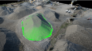
Geospatial based stockpile estimation solution helps measure, monitor, and compute the accurate volume of coal in mines, refineries, and power plants to digitize inventory management processes and optimize operational costs.
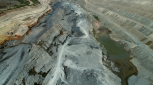
Slope Analysis:
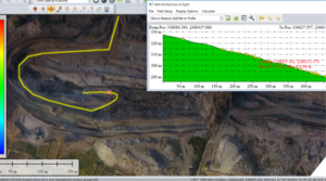
The Stability of the slopes is crucial for safe operations and a failure of slope in a working area of mine can give rise to a significant economic loss. The data captured from the site is converted into 3d point cloud data generated through the image feature point extraction integrated with accurate GPS ground control points. To visualize the image of the slope, the 3d model is created which is used to identify the nature of the slope. Slope failures are an inevitable aspect of economic pit slope designs in the mining industry.
Video Monitoring:
UAVs based on different kinds of sensors could acquire multi-source data for continuous monitoring and the centimeter-scale images could be obtained rapidly when the UAV flew at low altitudes. It has a huge advantage in monitoring in mining compared to traditional measurements or remote sensing technology, which have been favored by researchers and workers.
Road Monitoring:
With mine drone surveying, you don’t need to leave the office to troubleshoot any of it. Because the 3D survey is accurately mapped and rendered, you can measure grades and cross-slopes directly in your web browser. Check road widths and windrow heights in a couple of clicks and ensure they meet efficiency and safety requirements.
Blast Analysis:
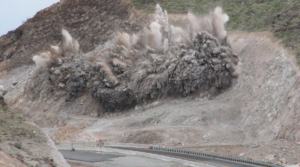
Pre-Blast: – Pre Blast surveying includes the information that can be obtained from a drone survey includes rock type variation in a bench, face angle, pre-blast block condition, and pre-blast volumes.
Post Blast: – Post-blast surveying provides data for measuring post-blast volume, and visual assessment of blast results such as muck pile shape, back damage, and distribution and fragmentation.